Hello Friends.
As a former East Coaster I, like almost everyone on the east coast, used to pay close attention to the hurricane forecasts. There’s even a season for them — a whopping 6 month long time period from June 1st through November 30th. As of today’s newsletter, hurricane season is in full swing…. as are the rescue and recovery efforts from the devastation of Hurricane Helene.
This newsletter is dedicated to the victims and survivors of hurricanes. There is a section at the end with links to various nonprofits who are working tirelessly to help those left in the wake of Hurricane Helene. If you’re able to make a donation, I’m certain they would be most grateful.
xo ~ Suzanne
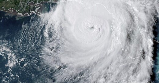
Last Thursday evening, September 27th, at approximately 11:10pm EST, Hurricane Helene made landfall in the Big Bend area of Florida — where the state’s panhandle curves down towards the peninsula.
Rated as a Category 4 hurricane (bringing 140mph winds), it also boasted an impressive width of approximately 420 miles.
Hurricane Helene has earned notoriety for its power and destruction. It’s the most powerful hurricane to hit the Big Bend area of Florida, the 14th most powerful to hit the US, and the third largest to hit the US since records began (two previous hurricanes tie at 460 miles wide: Ida in 2017 and Opal in 1996). It remained as a hurricane for 6 hours.
Its path through Florida, Georgia, Tennessee, the Carolinas, Kentucky and Virginia brought record-breaking rainfall and unfathomable devastation — the extent of which is yet to be fully understood. As of writing this, the death toll has climbed to 213 and will only continue to climb. Moody’s Analytics predicts $15 to $26 billion in property damage. The U.S. Department of Agriculture estimates crop losses could trigger $7 billion in insurance payouts. According to a NPR report, “hurricanes contribute to thousands of deaths in the U.S. each year — many times the reported number”.
The true toll from Hurricane Helene will only be known in time and the losses will stretch on for years.
Social media has been flooded with photos, videos, personal pleas for help and first-hand accounts of the experience and its aftermath — striking a primal chord that hasn’t quite been captured on our major news networks.
What is a hurricane?
A hurricane is a type of storm called a tropical cyclone, which forms over tropical or subtropical waters. It is a rapidly rotating storm system with a low-pressure center, a closed low-level atmospheric circulation, strong winds, and a spiral arrangement of thunderstorms that produce heavy rain and squalls. When a storm's maximum sustained winds reach 74 mph, it is called a hurricane.
Hurricanes originate in the Atlantic basin — which includes the Atlantic Ocean, Caribbean Sea, and Gulf of Mexico, the eastern North Pacific Ocean, and, less frequently, the central North Pacific Ocean.
NOAA's National Hurricane Center predicts and tracks these massive storm systems, which occur, on average, 12 times a year in the Atlantic basin.
These are one of nature’s most powerful storms.
The Saffir-Simpson Hurricane Wind Scale
The Saffir-Simpson Hurricane Wind Scale is a 1 to 5 rating, or category, based on a hurricane's maximum sustained winds. The higher the category, the greater the hurricane's potential for property damage.
Developed in 1971 by civil engineer Herbert Saffir and meteorologist Robert Simpson, the Saffir-Simpson scale divides storms according to sustained wind intensity in an attempt to explain storms on a scale similar to the Richter scale for earthquakes.
It should be noted that the Saffir-Simpson scale does not take into account other potentially deadly hazards such as storm surge, rainfall flooding, and tornadoes.
Below are the hurricane categories, wind speeds, and how they’re described.
Category 1 | 74-95 mph
Very dangerous winds will produce some damage: Well-constructed frame homes could have damage to roof, shingles, vinyl siding and gutters. Large branches of trees will snap and shallowly rooted trees may be toppled. Extensive damage to power lines and poles likely will result in power outages that could last a few to several days.
Category 2 | 96-110 mph
Extremely dangerous winds will cause extensive damage: Well-constructed frame homes could sustain major roof and siding damage. Many shallowly rooted trees will be snapped or uprooted and block numerous roads. Near-total power loss is expected with outages that could last from several days to weeks.
Category 3 (major) | 111-129 mph
Devastating damage will occur: Well-built framed homes may incur major damage or removal of roof decking and gable ends. Many trees will be snapped or uprooted, blocking numerous roads. Electricity and water will be unavailable for several days to weeks after the storm passes.
Category 4 (major) | 130-156 mph
Catastrophic damage will occur: Well-built framed homes can sustain severe damage with loss of most of the roof structure and/or some exterior walls. Most trees will be snapped or uprooted and power poles downed. Fallen trees and power poles will isolate residential areas. Power outages will last weeks to possibly months. Most of the area will be uninhabitable for weeks or months.
Category 5 (major) | 157 mph or higher
Catastrophic damage will occur: A high percentage of framed homes will be destroyed, with total roof failure and wall collapse. Fallen trees and power poles will isolate residential areas. Power outages will last for weeks to possibly months. Most of the area will be uninhabitable for weeks or months.
Ensemble Streamflow Prediction Forecasts
The Ensemble Streamflow Prediction System, or ESP, is a long-term hydrologic forecast which utilizes historical precipitation data as input to the River Forecast Center’s Hydrologic Model. The long-range forecasts provide information on future river stage, flow and/or volume at river forecast sites across the Southeast.
In a nutshell, ESP provides an estimate for the water flow of rivers. ESP forecasts are issued once a month for the upcoming 30-90 day period.
What made Hurricane Helene so different from others before it?
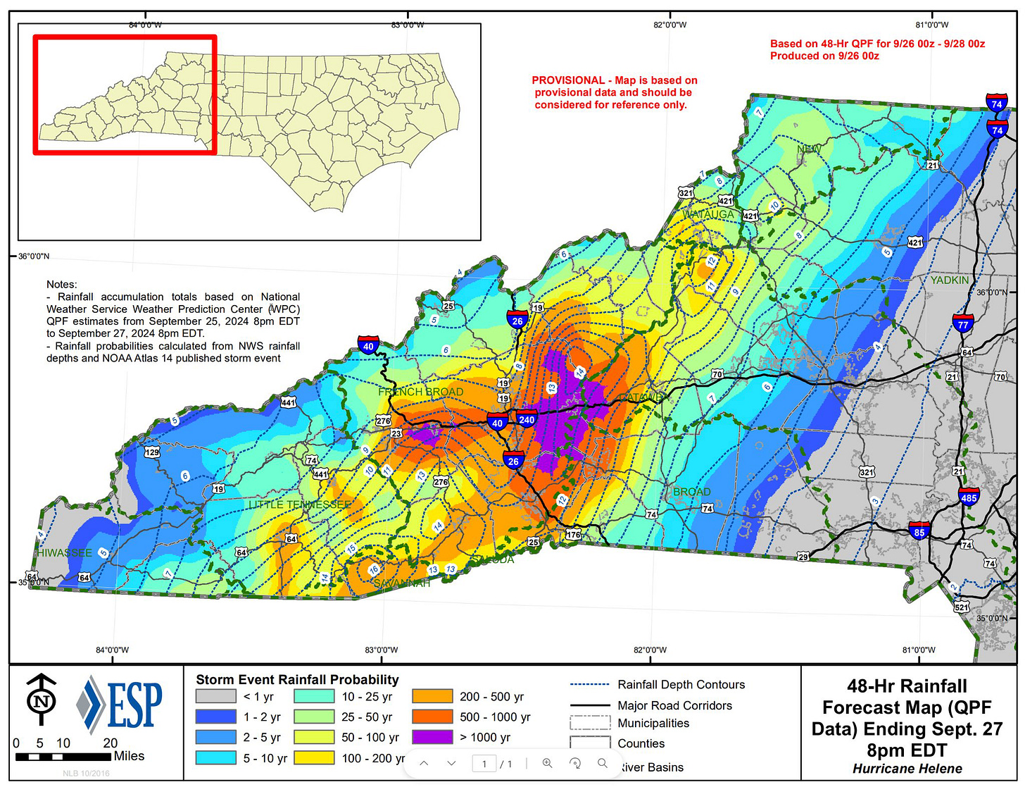
According to the ESP map (below) from the National Weather Service / NOAA, the regions in North Carolina to be affected by Hurricane Helene were forecast to a 500-1000 year rainfall probability event. Some areas in the middle were predicted to experience a greater than 1000-year event. That’s quite something to get my head wrapped around.
Fancy helping those in need from Hurricane Helene?
Here’s a short list of some amazing grass-roots organizations that have boots on the ground to help those in need. If you’re able to donate I am certain they would be most appreciative.
World Central Kitchen (a personal fave)
Wings of Rescue (animal rescue)
Cajun Navy Relief (Website appears to be down — either due to connectivity in that part of the US and/or lots of web traffic. Alternately, you can visit their FB page: https://www.facebook.com/CajunNavyRelief)
Mountain Mule Packers Ranch (plus their FB page: www.facebook.com/mountainmulepackersranch)


